3D layout web view, power flow model, Solargis integration
pvDesign - backend v9.18.5, frontend v4.12.0
This month we released many great new features, with improvements across the entire software. The release of the 3D layout web view feature makes it much easier to use the topography analysis capabilities of pvDesign. The power flow model is a new document allowing users to deeply study the electrical characteristics of the PV plant.
We also made two changes to the overhead line module which make it easier to customize the design. It is now possible to add restricted areas to the OHL path which will be avoided by the tower spotting algorithm.
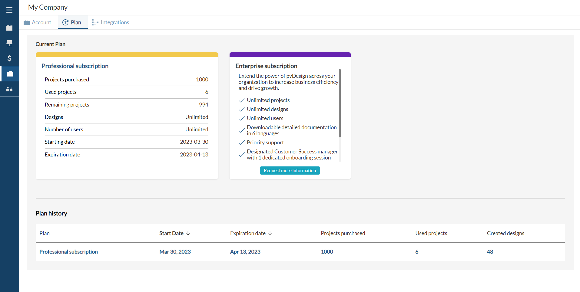
Finally, we released a big change to the license page. It is now easier to review the current license, including the amount of time left and the projects remaining.
New Features
In March, the following features were released:
- 3D layout web view: It is now possible to visualize the 3D layout in the web interface, instead of downloading the Layout 3D DWG document. To do so, head over to the 3D tab in the design view. The 3D view shows the terrain, the structures (fixed or tracker) and their piles, the power stations, the roads, and the area boundaries. It also shows the earthworks platforms in yellow.
- Power Flow Model: pvDesign will now calculate the Single Generator Equivalent System (SGES) of the PV plant, based on the WECC guideline. The SGES includes the overhead line, substation transformers, MV collectors for each generator (either PV or BESS), power station transformers, and generators. The SGES can be reviewed in the power flow document spreadsheet, which contains the electrical parameters of each system (impedance, voltage, capacity, etc), and a schematic diagram of the SGES. The listing of cables has also been updated to include new parameters such as the reactance. Finally, the voltage drop calculation in cable sizing now considers the reactance of MV cables, as well as the power factor estimation.
- Subscription plans: We remade the license information tab in the My Company page. In the new Plan tab, you will find detailed information regarding your subscription plan, as well as the history of previous plans you were subscribed to in the past. The new version is easier to understand than the previous design of the page, while including more information.
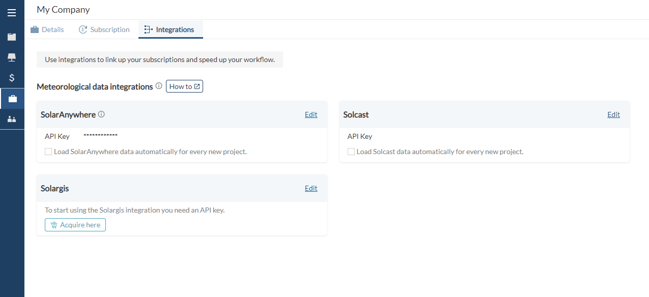
- Solargis integration: Automatically get meteorological data from Solargis when uploading a site to pvDesign. To do so, you will need a Solargis TMY API subscription. Once you have your key, head over to the My Company page in pvDesign, Integrations tab, and add your key under the Solargis section.
- Restricted areas for overhead lines: Restricted areas will now be considered when placing the tower of the OHL. The tower spotting algorithm will try not to place towers inside the restricted areas, and if it does, a warning will be shown in the Overhead Line Layout. Additionally, if the OHL path crosses an available area, a new restricted area will be automatically generated by pvDesign. This automatic restricted area will be calculated by creating a buffer around the OHL path.
- Extra high voltage for Substation and OHL: The maximum limit for the high voltage level input has been increased to 550 kV. The higher voltage level is required in order to use a double busbar substation with duplex circuit arrangement and a minimum of 3 conductors per phase.
Bug fixes and improvements
In March, the following minor improvements and bug fixes were released:
- Fixed some translation errors in the documentation in German.
- Fixed an issue that was causing the power factor estimation to be wrong in some corner cases.
- Fixed a bug which caused roads to cross over structures.
- Fixed a bug which was causing pages to overlap in the MV-LV SLD document.
- Fixed a bug which was causing the power factor to be considered erroneously when regular blocks and string inverters were used.
- Fixed an issue which was causing the client logo to be missing from the OHL layout.
- Fixed an issue with the layout of roads when an area had inner holes.
- Improved the color representation in the web layout 3D.
- Fixed an issue in the layout of cables which was causing simulation failures.
- Fixed a bug which was causing the area boundaries to be missing from the 3D documents.
- Fixed a bug which caused fixed structures to appear as trackers in the bill of quantities.
- Increased the limits to allow switching and breaking stations to 100 MVA and 2100 A.
- Improved the power transformer SLD to include the resistance and reactance information.
- Fixed a bug which occurred when using earthworks and there was a small overlap between a platform and the substation area.
- Fixed bugs related to the earthworks algorithm and which were causing simulation failures.
- Improved the design of the sliders used in the maps.
- The calculated voltage drop value of the OHL is now displayed in the interface.
- Improved error reporting when drawing a battery area inside an inner hole.
- Improved the behavior of maps in general.
- Improved error handling and reporting in the interactive site creator.
- Changed the order of the sections in the OHL tab in the design process page, and fixed styling issues.
- The installed area is now shown in the design details.
- Improved the automatic correction of complex areas in the interactive site creator.