Trying to define your site by uploading a file? Follow this article step by step to import all of the details from your file!
Up to now, RatedPower users were not allowed to import any type of files other than KML/KMZ formats for their site definition. With the release of this new feature, users can easily read shapefiles into RatedPower, preserving more site details from original resources with just a few steps.
Upload Shapefile
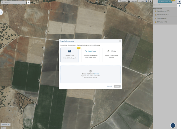
- On our internal site creation page, you can find the "Import site info" button on the right sidebar, by clicking it you will see the pop-up window where you can select which type of information you would love to have for site creation.
There are three options here:
- Upload a file: you will be able to upload the file that's prepared in advance for your site definition. It can be either a group of certain elements to import or the full site definition. The formats supported for this option include: .KML/.KMZ, ESRI shapefile package or its .zip version(with a size limit of 5MB);
- Select an existing site from the project: from this option, you will enter the list of existing sites that were created historically for this project, you can choose any of them to start your new design process;
- Import a parcel from PRISM: we have enabled this option for all PRISM users to easily integrate all information of a suitable site from PRISM into RatedPower, streamlining the process from site prospecting to solar plant development.
- On the same page, you can either drag files into the pop-up window or click on "Upload a file" and select from your file browser. We recommend bulk uploading what's in the package and excluding the unsupported file (.qmd format). Note that your files must include the below four mandatory formats for RatedPower to successfully read:
.shp: The main file that stores the geometry
.shx: The index that stores the index of the geometry
.dbf: The database that stores all the information about the features
.prj: The file that stores the coordinate system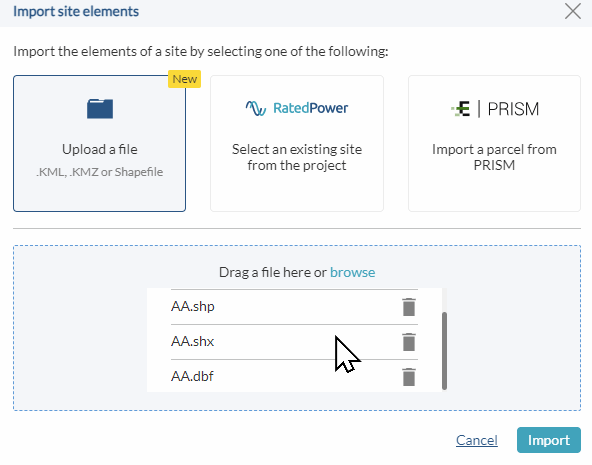
1. All these four files should have the same prefix, e.g.
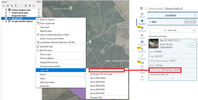
polygons.shp, polygons.shx, polygons.dbf, polygons.prj2. The ESRI shapefile package should be saved in the correct CRS(Coordinate Reference System) for the site location. The easiest way is to have it match with the CRS shown on RatedPower's "Site Detail".
- Once you have imported the package shapefile, you should see the files being processed and read.
A failure in the file importing could give an error. You could retry the importing process, making sure all the files are following the mandatory requirements mentioned above.
The most common reason would be the unmatching CRS(Coordinate Reference System) used for geometries inside the package of shapefiles.
Note that when an error is identified in specific elements, the software can still draw the rest of them, but you will get a "We've identified errors with certain elements on the site that prevented them from being rendered in RatedPower." message along with it.
These pages could also be helpful to you when you are dealing with challenging files:
For any other questions or more information regarding this topic, you can contact us at: support@ratedpower.com