Optimize your designs by performing topographic analysis considering different slopes' directions and explore the overhead line details directly from the design's map view.
pvDesign - backend v15.1.9, frontend v5.6.0
In December, we released a new feature to enhance the software’s topographic analysis with the objective of allowing our users to optimize their plant’s production. This upgrade allows the differentiation of the north and south slopes, which gives the user a deeper understanding of the structure’s installation. Additionally, we added the overhead line final path and its tower’s information on the design’s map which gives the user more ease in iterating their designs to get a more optimal design.
New Features
- Differentiate the direction of the slopes when performing your topographic analysis: this feature will allow users to intuitively distinguish, discard, or apply earthworks between north and south-facing structures in the same design, allowing them to make a much more detailed topographic analysis. By offering this capability within our product, we intend for users to gain deeper insight, have greater control over the structures to be removed, and optimize their decision-making processes. Click here to learn how the pvDesign topography tool works.
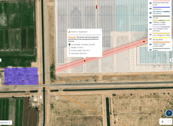
- Overhead line information on the map: Users can now visualize the overhead line’s final path in the map of the design along with the position of the towers. The feature also includes showing information related to each tower and span upon the click, the information includes the coordination, the height, and the angle of towers, the span lengths, as well as any warning caused by requirements of the line.
Bug fixes and improvements
- Added a new overhead line conductors to the public database.
- Fixed a bug related to the color appearing when getting details of a topography rejected structure.
- Added two dropdowns in the settings tab within the Design Process to ensure clarity when knowing which inputs correspond to documentation: Design Settings and Documentation Settings.
- Improved with an updated toggle introducing the information for a client’s name and logo in settings within the Design Process.
- Added the segment length when drawing lines in ISC.
- Fixed a bug caused by precision issues from MV lines.
- Made muVocSpec optional when reading PAN files. This improvement makes the muVocSpec parameter of PAN files optional. If the parameter is not present, it will be calculated using the one diode model.
- Fixed validation that checked that MV lines had at least two distinct points. MV cables with less than 2 points are ignored.
- Improved some code calculations that affected the road layout to reduce the simulation duration time.
- Fixed a bug that was causing earthworks limits to not work correctly after the release of the differentiation of north-south slopes.
- Updates per area road layout values when validating roads globally to ensure it is possible to deactivate inputs per area when changing site.
- Improved the algorithm to cross MV lines over roads.
- Fixed the polygon definition used for drawing the structures in the layout for the KML format.